This page contains the following sections:
General
What is the Forest Service mission?
The Forest Service mission is to sustain the health, diversity, and productivity of the Nation’s forests and grasslands to meet the needs of present and future generations.
What is molybdenum?
Molybdenum is a metal that is often extracted as a byproduct of copper production and is used to make steel alloys. Although molybdenum is not the primary target mineral of the Resolution Copper mine, the mine would also extract molybdenum that would be processed and sold.
What is NEPA?
The National Environmental Policy Act (NEPA) was signed into law on January 1, 1970. NEPA requires federal agencies to assess the environmental effects of their proposed actions prior to making decisions. The range of actions covered by NEPA is broad and includes making decisions on permit applications, adopting federal land management actions, and constructing publicly-owned facilities or infrastructure. Using the NEPA process, agencies evaluate the environmental and related social and economic effects of their proposed actions. Agencies also provide opportunities for public review and comment on those evaluations.
Who does NEPA apply to?
Every agency in the executive branch of the Federal Government has a responsibility to implement NEPA. In NEPA, Congress directed that, to the fullest extent possible, the policies, regulations, and public laws of the United States shall be interpreted and administered in accordance with the policies set forth in NEPA. To implement NEPA’s policies, Congress prescribed a procedure, commonly referred to as “the NEPA process” or “the environmental impact assessment process.”
When does an agency have to implement NEPA?
NEPA’s procedural requirements apply to a Federal agency’s decisions for actions, including financing, assisting, conducting, or approving projects or programs; agency rules, regulations, plans, policies, or procedures; and legislative proposals. NEPA applies when a Federal agency has discretion to choose among one or more alternative means of accomplishing a particular goal.
Frequently, private individuals or companies will become involved in the NEPA process when they need a permit issued by a Federal agency. When a company applies for a permit (for example, for crossing federal lands or impacting waters of the United States) the agency that is being asked to issue the permit must evaluate the environmental effects of the permit decision under NEPA. Federal agencies might require the private company or developer to pay for the preparation of analyses, but the agency remains responsible for the scope and accuracy of the analysis.
What does NEPA do?
The NEPA process must be completed before an agency makes a final decision on a proposed action. Good NEPA analyses should include a consideration of how NEPA’s policy goals will be incorporated into the decision to the extent consistent with other considerations of national policy. NEPA does not require the decision-maker to select the environmentally preferable alternative or prohibit adverse environmental effects. Indeed, decision-makers in Federal agencies often have other concerns and policy considerations to take into account in the decisionmaking process, such as social, economic, technical or national security interests. But NEPA does require that decision-makers be informed of the environmental consequences of their decisions.
What does the EIS process consist of?
- The publication of a Notice of Intent (NOI), stating the agency’s intent to prepare an EIS for a particular proposal, kicks off the EIS process. The NOI is published in the Federal Register, and provides some basic information on the proposed action in preparation for the scoping process.
- The scoping process is the best time to identify issues, determine points of contact, establish project schedules, and provide recommendations to the agency. The overall goal is to define the scope of issues to be addressed in depth in the analyses that will be included in the EIS.
- Agencies then submit a draft EIS for public comment. The Environmental Protection Agency (EPA) publishes a Notice of Availability in the Federal Register informing you and other members of the public that the draft is available for comment. The comment period is at least 45 days long; however, it may be longer based on requirements spelled out in the agency specific NEPA procedures or at the agency’s discretion. During this time, the agency may conduct public meetings or hearings as a way to solicit comments. The agency will also request comments from other Federal, State, Tribal, and local agencies that may have jurisdiction or interest in the matter
- One key aspect of a draft EIS is the statement of the underlying purpose and need. The purpose and need statement explains to the reader why an agency action is necessary, and serves as the basis for identifying the reasonable alternatives that meet the purpose and need. In addition to the purpose and need, identification of reasonable alternatives, and the environmental effects of the alternatives, the draft EIS will contain a description of the environment that would be affected by the various alternatives.
- When the public comment period is finished, the agency analyzes comments, conducts further analysis as necessary, and prepares the final EIS. In the final EIS, the agency must respond to the substantive comments received from other government agencies and from members of the public. The response can be in the form of changes in the final EIS, factual corrections, modifications to the analyses or the alternatives, new alternatives considered, or an explanation of why a comment does not require the agency’s response. When it is ready, the agency will publish the final EIS and EPA will publish a Notice of Availability in the Federal Register. The Notice of Availability marks the start of a waiting period, which is a minimum of 30 days that must pass before the agency can make a decision.
- The Record of Decision is the final step for agencies in the EIS process. The ROD is a document that states what the decision is; identifies the alternatives considered, including the environmentally preferred alternative; and discusses mitigation plans, including any enforcement and monitoring commitments. In the ROD, the agency discusses all the factors, including any considerations of national policy that were contemplated when it reached its decision on whether to, and if so how to, proceed with the proposed action. The ROD will also discuss if all practical means to avoid or minimize environmental harm have been adopted, and if not, why they were not.
Has NEPA been initiated on this project? Will NEPA be required?
The NEPA process for the proposed GPO and the Land Exchange was initiated when the Notice of Intent to Prepare an Environmental Impact Statement (EIS) was published in the Federal Register.
What is an EIS?
"EIS" is the abbreviation for environmental impact statement, a document prepared to describe the effects of proposed activities on the environment. "Environment," in this case, is defined as the natural and physical environment and the relationship of people with that environment. This means that the "environment" considered in an EIS includes land; water; air; structures; living organisms; environmental values at the site; and social, cultural, and economic factors. An "impact" is a change or consequence that results from an activity. Impacts can be positive or negative, or both. An EIS describes impacts, as well as ways to "mitigate" impacts. To "mitigate" means to lessen or remove negative impacts. Therefore, an EIS is a document that describes the impacts on the environment as a result of a proposed action. It also describes impacts of alternatives, as well as plans to mitigate the impacts.
What is the “Proposed Action” to be analyzed in the EIS?
The proposed action is to approve the proposed plan of operations as submitted by Resolution Copper Mining LLC (Resolution Copper) and to complete the land exchange as directed by Congress under Section 3003 of the National Defense Authorization Act. The EIS will analyze three components. 1) The EIS will analyze the effects of approval of the proposed plan of operations. The Forest Service is required by federal regulation to respond to the proposed plan of operations. 2) The EIS will analyze the effect of the exchange of lands between the federal government and Resolution Copper. 3) The EIS will analyze whether to amend the Tonto National Forest Land and Resource Management Plan to facilitate the proposed mining operations and the land exchange.
What is “Scoping”?
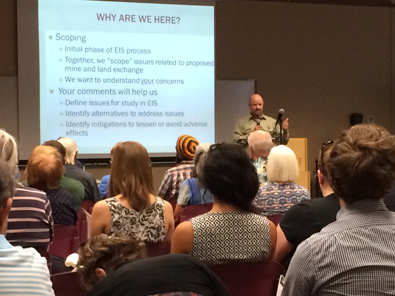
The first step in the NEPA process is called “scoping”. Scoping is a process of seeking input from within the agency, from the public, and from other government agencies in order to define the scope of issues to be addressed in depth in the EIS. The scoping process will typically identify people or organizations who are interested in the proposed action, identify the significant issues to be analyzed in the EIS, identify and eliminate from detailed review those issues that will not be significant or those that have been adequately covered in prior environmental review, determine the roles and responsibilities of lead and cooperating agencies, identify gaps in available data, and identify other environmental review or permits and consultation requirements that will be integrated with the EIS.
Public meetings are often part of the scoping process. Forest Service officials held five open-house public meetings during the scoping period for the Resolution Copper Project and Land Exchange EIS.
- March 31, 2016 – Queen Valley Recreation Hall, 1478 East Queen Valley Drive, Queen Valley, AZ
- April 4, 2016 – Superior High School, 100 Mary Drive, Superior, AZ
- April 5, 2016 – Elks Lodge 1775 East Maple Street, Globe, AZ
- April 6, 2016 – Southwest Regional Library, 775 North Greenfield Road, Gilbert, AZ
- June 9, 2016 – Central Arizona College, San Tan Campus, 3736 E Bella Vista Rd, San Tan Valley, AZ
Individuals who were interested in submitting comments but were unable to attend a public meeting still could submit comments in a variety of ways:
- Send written comments via postal mail to:
Resolution EIS Comments
PO Box 34468
Phoenix, AZ 85067-4468 - Leave a voicemail or send fax to 1-866-546-5718
Land Exchange
Where are the parcels involved in the land exchange located?
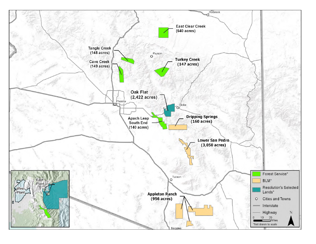
There are 8 parcels of land within the state of Arizona that are listed in the legislation as part of the land exchange. These parcels are undergoing an appraisal process to determine fair market value of the properties. For specific parcel information, see maps.
What led to the initiation of this land exchange?
In December 2014, Congress passed the Carl Levin and Howard P. ‘Buck’ McKeon National Defense Authorization Act for Fiscal Year 2015 (NDAA). Section 3003 of this law authorizes and directs the Secretary of Agriculture to administer a land exchange between Resolution Copper and the United States Forest Service, which will convey 2,422 acres of Forest Service land in the area of the proposed mine to Resolution Copper.
Where is the Forest Service land being proposed for exchange to Resolution Copper?
The land being transferred to Resolution Copper is located east of the Town of Superior in the area of the Oak Flat Campground.
What would the federal government (taxpayers) get in return?
Resolution Copper will convey private land parcels to the Federal Government consisting of 5,376 acres of private land on 8 parcels located elsewhere in Arizona.
Why aren’t environmental studies being done before the land exchange?
This particular land exchange occurred as an Act of Congress, which does not always require environmental studies before land exchanges are completed. Because this project will have impact on federal land, NEPA will require that a thorough environmental analysis be done on the entire project, including public lands and the exchanged land.
Once the EIS is complete and the land has been transferred into private ownership, how will mitigation measures apply?
The EIS can identify issues and recommend mitigation measures for lands that will be transferred into private ownership. Although the Forest Service will no longer have regulatory jurisdiction for those lands, Resolution Copper will still be required to comply with numerous federal and state environmental laws, which address air quality, hazardous waste management, mine safety, mine reclamation, and other aspects of the proposed mine. The Forest would retain jurisdiction for the tailings storage facility and other mine infrastructure that would be located on approximately 4,500 acres of national forest lands not subject to the land exchange.
What will happen to Oak Flat Campground and Apache Leap?
The Oak Flat Campground will be conveyed to Resolution Copper during the land exchange. As a condition of conveyance of the Federal land, Resolution Copper must agree to provide access to the surface of Oak Flat Campground to members of the public, until such a time that operations of the mine preclude that access due to safety concerns. Apache Leap is not part of the area to be conveyed to Resolution Copper; rather, some private lands currently owned by Resolution Copper near Apache Leap would be conveyed to the Forest Service during the exchange. Apache Leap will be designated a Special Management Area, and will be managed to protect the cultural, archaeological, and historical resources found there.
Representatives from several Apache Organizations oppose this legislation and are occupying Oak Flat Campground. What is the Forest Service doing about it?
Allowing tribal members to occupy Oak Flat is part of our continued engagement to address tribal concerns. The Forest Service is working with tribal members to permit this activity.
Land Appraisal
What Standards will be utilized in preparation of the appraisals?
The Uniform Standards of Professional Appraisal Practice (USPAP), the Uniform Appraisal Standards for Federal Land Acquisitions (UASFLA), and section 254.9 of title 36, Code of Federal Regulations will be utilized in the appraisal assignment. USPAP is the industry standard for real estate appraisals. UASFLA is an additional set of appraisal standards for federal land acquisitions and exchanges that are required by the Act. US Forest Service appraisal procedures for land exchanges are contained in 36 CFR 254.9.
Has an appraiser been selected for the project?
Yes. The Forest Service and Resolution Copper agreed on an appraiser. This complies with Section 3003 of the National Defense Authorization Act for Fiscal Year 2015 (the Act), which requires the joint selection of an appraiser who is determined by both parties to be qualified to complete appraisals supporting the exchange.
Under whose direction are the appraisals completed?
The appraisals are completed under the direction of the Forest Service. The Forest Service contracting officer and review appraiser will issue detailed instructions to the appraiser which define standards to be followed, products to be delivered, protocols for interactions with the parties, specific instructions related to requirements of the Act, as well as other instructions as required.
Will the Forest Service simply accept the values from appraisals prepared by the Appraiser?
The completed appraisal reports will go through a stringent review process by the assigned Forest Service review appraiser. It is the reviewer’s job to ensure that the appraisal follows the appraisal instructions, USPAP and UASFLA standards, Federal regulations, and the special requirements found in the Act. The review appraiser ensures that the values concluded by the appraiser are sound and well-supported.
Does the Act specify how the properties will be appraised?
The Act specifies “a detailed income capitalization approach analysis of the market value of the Federal land which may be utilized, as appropriate, to determine the value of the Federal land.” The income capitalization approach is one of three commonly used approaches used for real property appraisals; the other two are the sales comparison approach and the cost approach. While the approaches used to value the property is ultimately the appraiser’s to make, a commonly used approach for valuing mineralized properties is the capitalization of royalty income.
How are U.S. taxpayers protected if the quantity of minerals produced from the Federal Lands exceed that which was analyzed in the appraisal?
Section (e) of the Act provides for a Value Adjustment Payment to the United States which requires annual production reporting by RCM. If production of locatable minerals exceeds that used in the Income Capitalization Approach developed in the appraisal, RCM will be required to make a payment annually to the United States based upon the excess production.
What sources of information will the appraiser use to determine the potential income for the Federal parcel?
It will be necessary for the appraiser to utilize multiple sources of information, including ore body data and production cost estimates from RCM, as well as outside expertise from geologists, mining engineers, and other industry experts versed in development of mining properties of a similar scale. The appraiser will not rely solely on information provided by RCM.
Will the appraisals be made available to the public?
The Act specifies that the appraisal reports supporting the land exchange will be made available for public review prior to completion of the land exchange. The reports will be made available after they are reviewed and approved by the Forest Service review appraiser.
How long are the appraisals valid?
Under the Act, the Forest Service is not required to reappraise or update the final appraised value for a period of 3 years beginning on the date of the approval by the Secretary of the final appraised value; or at all, in accordance with 36 CFR 254.14 after an exchange agreement is entered into by the Forest Service and RCM.
General Plan of Operations

Where will the mine be located?
The mine would be located near the Town of Superior, approximately 65 miles east of Phoenix, Arizona, in the area of the former Magma Copper Mine. The deposit to be mined occurs nearly 7,000 feet beneath the earth’s surface.
What is panel caving?
With this technique, a series of horizontal tunnels would be constructed below the ore body. The process begins with an initial round of explosives at the bottom of the ore body to break up the rock. Then rock is funneled downward and removed. The void created in the removal process allows gravity to continue forcing the ore body downward. Automated loaders transfer the ore onto trains, where it is transported, crushed, and then conveyed to the surface for additional processing.
What is subsidence?
Subsidence is the gradual caving in or sinking of an area of land. In the context of underground mining, subsidence is the lowering of the Earth's surface due to collapse of bedrock and unconsolidated materials (sand, gravel, silt, and clay) into underground mined areas.
How much land subsidence is expected from this underground mine?
RCM predicts that land subsidence is expected to occur directly above the underground mine, and is expected to begin occurring after approximately two years of operation. After 40 years of panel cave mining, the subsidence is estimated to be, on average, about 500ft deep and reach a depth of 1,000ft at its deepest point. The magnitude of subsidence and associated effects to the environment will be analyzed in the EIS.
Where will the mine facilities, including transmission lines, be located, and what is the electricity source for the mine?
The mine facilities, including transmission lines, power source, and water treatment facility, are identified in the General Plan of Operations that was submitted by Resolution Copper and is available on the Forest’s website for the project. Power would be sourced from the Salt River Project and transmitted to the mine site via new transmission lines and substations that are identified in Section 3.5.1 of the General Plan of Operations.
Will the 560-acre privately owned filtration plant and loadout facility parcel adjacent to the MARRCO corridor be included in the EIS analysis?
Yes. Even though this parcel is privately owned by Resolution Copper, its proposed development is part of the overall development of the mine, and construction of the privately owned filtration plant is considered a “connected action” according to NEPA (see 40 CFR 1508.25 of the Council on Environmental Quality’s regulations implementing NEPA).
Where will the tailings be placed?
RCM has proposed construction of a 4,400 acre tailings storage facility on national forest lands in an area located northwest of the town of Superior and east of the town of Queen Valley. The proposed tailings storage facility location will be evaluated in the EIS. Alternatives will be developed, assessed, and outlined in the Draft EIS.
How big will the tailings deposit be?
The quantity of tailings is estimated at 1.5 billion tons of rock crushed to a fine sand by the end of the life of the mine. The design, configuration, affected area, and location of the proposed tailings storage facility may be modified based on the results of the EIS.
How will the copper be transported to market?
After crushing underground, the crushed ore would be transported to processing facilities located in Superior. The processing facilities would produce both copper and molybdenum concentrate. The molybdenum concentrate would be trucked directly to market from the processing facilities. The copper concentrate would be pumped as a slurry approximately 22 miles southwest to a loadout/filter facility. Once filtered, the concentrate would be sent to market via truck or rail.
Who is Resolution Copper and how did they acquire this land in the first place?
The General Plan of Operations was submitted to the Forest Service by Resolution Copper Mining, LLC. The discovery of the deposit was made by Magma Copper Company during exploratory drilling. In 1996, the company, along with the ‘Resolution deposit’, was acquired by BHP Copper Inc. However, shortly after, BHP ceased mining operations of the old Magma Mine and did not pursue further exploration. In April 2001, Kennecott Exploration signed an earn-in agreement with BHP Copper Inc. and initiated a five-year drilling program to further identify the size, grade and boundaries of the porphyry deposit while also initiating baseline environmental studies. During this time, Kennecott Exploration transferred all its assets and interests in the project to Resolution Copper Company, a wholly-owned Rio Tinto subsidiary.
By May 2004, Resolution Copper Company had met all the terms established in the earn-in agreement and became the managing member of the Resolution Copper Project.
Who is responsible for reclamation of the mine site after operations have ended, and how will reclamation be funded?
Resolution Copper would be responsible for reclamation of the mine. The company would also be required to post reclamation bonds, which are designed to provide funding for reclamation in the event that the Resolution Copper fails to complete reclamation. The Forest would require a reclamation bond for mining-related disturbance that would occur on Forest land. The Forest does not have authority to require reclamation bonds for mining-related disturbance that would occur on private or state lands associated with the project. In addition, because the Oak Flat parcel will be exchanged prior to mine development, the Forest will not have authority to require a reclamation bond for mining-related disturbance on the Oak Flat parcel. The State of Arizona has authority to require reclamation bonds on private, State, and Forest lands. The State bonding requirements for the various proposed mining operations and infrastructure are not currently known.
How will the mine site be reclaimed after mine operations have ended?
The proposed General Plan of Operations includes a proposed reclamation plan for disturbance on Forest lands. This document, along with other maps and figures, is available on the Forest’s website for the project. The proposed reclamation plan will be analyzed during the NEPA process. Alternatives to the proposed reclamation plan that would reduce adverse effects on Forest Service surface resources may be developed and analyzed during the EIS process.
What will the geographic and temporal bounds of analysis be in the EIS?
The geographic and temporal bounds of analysis will be determined specifically for each resource analyzed in the EIS. These resource-specific geographic and temporal bounds of analysis are not yet determined; however, the analysis will cover the geographic areas where direct, indirect and cumulative impacts would potentially occur during all phases of the mine, including mine construction, operation, closure, and reclamation. The geographic bounds of analysis will not be limited to the mine facilities that that are proposed on Forest lands. Mine facilities that are proposed on private lands (such as the loadout facility near San Tan Valley) will also be included in the EIS’s geographic bounds of analysis.
Will the EIS analyze the mine’s potential impacts regarding: air quality; biological resources; cultural resources; geology and minerals; noise and lighting; public health and safety; recreation resources; and socioeconomics?
Yes. The Forest Service will conduct studies to analyze the impacts that the proposed action and alternatives may have on these areas.